No edit summary |
(a little finetuning) |
||
| (4 intermediate revisions by 2 users not shown) | |||
| Line 1: | Line 1: | ||
{{redlinks}} |
{{redlinks}} |
||
| ⚫ | |||
| ⚫ | [[Hill Valley]], [[California]], is depicted in the [[Back to the Future trilogy]] in great detail. |
||
| ⚫ | |||
| ⚫ | The origin of the street numbering system is near the [[Hill Valley Railroad Station]].<ref>The corner of Main and Hill is at the 400 block of Hill, as shown by the corner street sign in 1985. In 2015, the Cafe 80s is located at 224 Main Street, which would be consistent with being on the corner of 2nd Street. Since in most cities, buildings on the corner at the origin are usually numbered 100 and 101 so that all addresses have at least 3 digits, 400 Hill St. is 3 blocks east of the origin, apparently the railroad tracks. Also, the railroad station was on the block north of Second St. in 1885, which matches that the Cafe 80's is on the block south of Second St. to have the address 224. This would also mean that Hill St., at the Essex Theater side of the square, might take the place of Third St.</ref> |
||
| ⚫ | |||
| + | {{Quote|He ''<nowiki>[</nowiki>[[Emmett Brown|Doc]]]'' sighed. That was one of the problems with time traveling. A couple of the roads he had expected to take ''[by [[bicycle]]]'' to get here ''[Mason Street]'' hadn't been built yet.|From ''[[Back to the Future Part II novelization|Back to the Future Part II]]'' by [[Craig Shaw Gardner]] (quote, page 159)}} |
||
| ⚫ | [[Hill Valley]], [[California]], is depicted in the [[Back to the Future trilogy]] in great detail. Not only are street addresses mentioned in the dialogue, but maps and a [[1955]] [[telephone directory]] page are shown as well. Two major state highways converge near [[Courthouse Square]], where [[U.S. Route 395]], running north-south along [[Main Street]] intersects with [[U.S. Route 8]], which runs east-west along [[Second Street]] and parallel to [[Hill Street]]. |
||
| ⚫ | |||
| ⚫ | In relation to the [[Hill Valley Courthouse|clock tower]], the [[Western Auto]] store and the [[Bank of America]] are to the '''north''' on Second Street. |
||
| ⚫ | The origin of the street numbering system is near the [[Hill Valley Railroad Station]].<ref>The corner of Main and Hill is at the 400 block of Hill, as shown by the corner street sign in 1985. In 2015, the Cafe 80s is located at 224 Main Street, which would be consistent with being on the corner of 2nd Street. Since in most cities, buildings on the corner at the origin are usually numbered 100 and 101 so that all addresses have at least 3 digits, 400 Hill St. is 3 blocks east of the origin, apparently the railroad tracks. Also, the railroad station was on the block north of Second St. in 1885, which matches that the Cafe 80's is on the block south of Second St. to have the address 224. This would also mean that Hill St., at the Essex Theater side of the square, might take the place of Third St.</ref> |
||
| ⚫ | The [[Town Theater]] is to the '''east''' of the clock tower, on a street whose name is not shown (although it was referred to in the [[Back to the Future first draft screenplay|first draft]] as '''Monroe Avenue''')<ref>Officer Foley of the NRC asks Marty, "Been in the vicinity of 2980 Monroe Avenue today?" and explains, "Over by the old Orpheum Theater." It's the same theater that houses the [[Assembly of Christ]].</ref>. The street, however, is identified as [[Hubbard Avenue]] in an ad for [[Statler Studebaker]].<ref>Found within the [[November 5]], [[1955]] issue of the ''[[Hill Valley Telegraph]]''</ref> After passing through the square in 1985, Marty continues east to get to [[Hill Valley High School]]. |
||
| ⚫ | In relation to the [[Hill Valley Courthouse|clock tower]], the [[Western Auto]] store and the [[Bank of America]] are to the '''north''' on Second Street. The [[McFly farm]] in [[1885]], and the [[Pohatchee Drive-In Theatre]] in 1955, appear to be located north of Hill Valley, as [[Marty McFly]] walks down the railroad tracks from the north, before reaching [[Hill Valley Railroad Station]]. |
||
| ⚫ | The [[Essex Theater]] is to the '''south''' of the clock tower, on the 400 block of Hill Street. |
||
| ⚫ | The [[Town Theater]] is to the '''east''' of the clock tower, on a street whose name is not shown (although it was referred to in the [[Back to the Future first draft screenplay|first draft]] as '''Monroe Avenue''')<ref>Officer Foley of the NRC asks Marty, "Been in the vicinity of 2980 Monroe Avenue today?" and explains, "Over by the old Orpheum Theater." It's the same theater that houses the [[Assembly of Christ]].</ref>. The street, however, is identified as [[Hubbard Avenue]] in an ad for [[Statler Studebaker]].<ref>Found within the [[November 5]], [[1955]] issue of the ''[[Hill Valley Telegraph]]''</ref> After passing through the square in [[1985]], Marty continues east to get to [[Hill Valley High School]]. With [[Jennifer Parker]], he walks back from the east side after the [[Battle of the Bands]]. |
||
| ⚫ | [[Lou's Cafe]] and the [[Texaco service station]] are to the '''west''' of the clock tower, on the 100 block of Main Street. |
||
| + | |||
| ⚫ | The [[Essex Theater]] is to the '''south''' of the clock tower, on the 400 block of Hill Street. When Marty rides on his skateboard from [[Doc's garage]] in 1985, he approaches from the south. In walking from 2 mile marker at the future site of [[Lyon Estates]] in 1955, he also approaches town from the south (in 2015, Doc flies from Lyon Estates from the west side on an east-west skyway). When Marty returns to 1985, he runs south toward the [[Twin Pines Mall|Lone Pine Mall]]. |
||
| + | |||
| ⚫ | [[Lou's Cafe]] and the [[Texaco service station]] are to the '''west''' of the clock tower, on the 100 block of Main Street. Marty travels west as he runs after George in 1955. When he arrives in town in 1885, he comes from the west side, where the railroad station is located a few blocks away from the square. |
||
==North-south streets== |
==North-south streets== |
||
| − | [[Mason Street]], where [[Biff Tannen]] lived in 1955, and [[Sycamore Street]], where [[George McFly]] and [[Lorraine Baines]] both had houses, were on a north-south line. |
+ | [[Mason Street]], where [[Biff Tannen]] lived in 1955, and [[Sycamore Street]], where [[George McFly]] and [[Lorraine Baines]] both had houses, were on a north-south line. Streets following a north-south route are [[Main Street]], [[North Avenue]], North [[Salt Lake Avenue]], South [[State Street]], and [[Temple Street]]. In addition, [[Maple Street]] and Riverside Drive (later [[John F. Kennedy Drive]]) are described as being "on the east end of town" by [[Sam Baines]], with the latter being a major north-south thoroughfare by [[1985]]. The [[Central Pacific Railroad]] tracks also ran through town north to south. |
==East-west streets== |
==East-west streets== |
||
| − | The numbered streets, ranging from "East 2nd Street" as far as "[[43rd Street]]", follow an east-west direction. |
+ | The numbered streets, ranging from "East 2nd Street" as far as "[[43rd Street]]", follow an east-west direction. Among the addresses seen in the phone book are "214 E. 2nd", "230 E. 3rd", "1438 W. 4th", "281 West 23rd", "2407 East 33rd" and "604 East 39th". Parallel streets running east to west are [[Hill Street]], [[Sandy Street]], and [[West Drive]]. [[Cherry Street]] intersected with Main Street. |
==Other throughfares== |
==Other throughfares== |
||
| Line 28: | Line 31: | ||
*[[Broadway]] {{C|East-west}} |
*[[Broadway]] {{C|East-west}} |
||
*[[Bothwell Street]] |
*[[Bothwell Street]] |
||
| − | *[[Business Center Road]] |
+ | *[[Business Center Road]] — location of [[CusCo]] in [[2015]], Marty's employer. |
*[[Cherry Street]] |
*[[Cherry Street]] |
||
*[[Colorado Street]] |
*[[Colorado Street]] |
||
| Line 43: | Line 46: | ||
*[[Hill Place]] |
*[[Hill Place]] |
||
*[[Hillsden Drive]] |
*[[Hillsden Drive]] |
||
| − | *[[Hoffer Street]] |
+ | *[[Hoffer Street]] |
*[[Jeremy Street]] |
*[[Jeremy Street]] |
||
*[[John F. Kennedy Drive]] (Riverside Drive in 1955) |
*[[John F. Kennedy Drive]] (Riverside Drive in 1955) |
||
| Line 55: | Line 58: | ||
*[[Navaho Street]] |
*[[Navaho Street]] |
||
*[[Nerual Circle]] |
*[[Nerual Circle]] |
||
| − | *[[Oakhurst Street]] |
+ | *[[Oakhurst Street]] — located south of downtown Hill Valley, across [[Eastwood Ravine]], at the [[Hilldale]] neighborhood. Marty McFly lived here in 2015 after wrecking his [[Toyota Hilux|truck]] nearby in 1985. |
*[[Oakwood Street]]? {{C|As Oakwd}} |
*[[Oakwood Street]]? {{C|As Oakwd}} |
||
*[[Orchard Drive]] |
*[[Orchard Drive]] |
||
| − | *[[Oriole Road]] |
+ | *[[Oriole Road]] — 2015 residence of [[Douglas J. Needles]], at 88 Oriole Road |
*[[Park Street]] |
*[[Park Street]] |
||
| − | *[[River Road]] |
+ | *[[River Road]] — road between [[Biff Tannen]]'s home on [[Mason Street]], and the [[Hill Valley High School]]. The road passes through a [[River Road Tunnel|tunnel]] that goes underneath [[Deacon's Hill]]. Biff wrecked his [[Ford Super De Luxe Convertible|car]] outside the tunnel on November 5, 1955, shortly after Marty took the ''[[Grays Sports Almanac]]'' from him. |
*[[Rose Circle]] |
*[[Rose Circle]] |
||
*[[Salt Lake Street]] |
*[[Salt Lake Street]] |
||
| Line 132: | Line 135: | ||
*[[12th Avenue]] {{C|Highest avenue number in 1955 phone directory}} |
*[[12th Avenue]] {{C|Highest avenue number in 1955 phone directory}} |
||
*[[Aspen Avenue]] |
*[[Aspen Avenue]] |
||
| − | *[[Benlea |
+ | *[[Benlea Avenue]] |
*[[Beryl Avenue]] |
*[[Beryl Avenue]] |
||
| − | *[[Broad Avenue]] |
+ | *[[Broad Avenue]] |
*[[Browning Avenue]] |
*[[Browning Avenue]] |
||
*[[Bryan Avenue]] |
*[[Bryan Avenue]] |
||
| Line 146: | Line 149: | ||
*[[Harrison Avenue]] |
*[[Harrison Avenue]] |
||
*[[Helm Avenue]] |
*[[Helm Avenue]] |
||
| + | *[[Hubbard Avenue]] |
||
*[[Hollywood Avenue]] |
*[[Hollywood Avenue]] |
||
*[[Geltz Avenue]] |
*[[Geltz Avenue]] |
||
Latest revision as of 11:38, 12 October 2017
 |
Hill and Main Street signage in 1985.
Second Street signage in 1955.
- "He [Doc] sighed. That was one of the problems with time traveling. A couple of the roads he had expected to take [by bicycle] to get here [Mason Street] hadn't been built yet."
- —From Back to the Future Part II by Craig Shaw Gardner (quote, page 159)
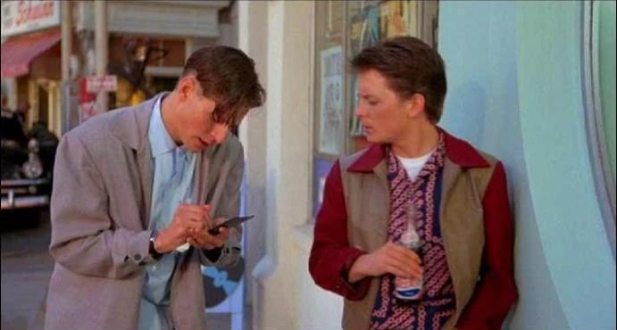
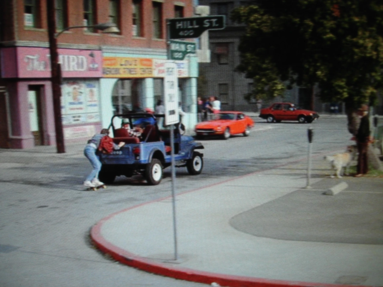
Hill Valley, California, is depicted in the Back to the Future trilogy in great detail. Not only are street addresses mentioned in the dialogue, but maps and a 1955 telephone directory page are shown as well. Two major state highways converge near Courthouse Square, where U.S. Route 395, running north-south along Main Street intersects with U.S. Route 8, which runs east-west along Second Street and parallel to Hill Street.
The origin of the street numbering system is near the Hill Valley Railroad Station.[1]
In relation to the clock tower, the Western Auto store and the Bank of America are to the north on Second Street. The McFly farm in 1885, and the Pohatchee Drive-In Theatre in 1955, appear to be located north of Hill Valley, as Marty McFly walks down the railroad tracks from the north, before reaching Hill Valley Railroad Station.
The Town Theater is to the east of the clock tower, on a street whose name is not shown (although it was referred to in the first draft as Monroe Avenue)[2]. The street, however, is identified as Hubbard Avenue in an ad for Statler Studebaker.[3] After passing through the square in 1985, Marty continues east to get to Hill Valley High School. With Jennifer Parker, he walks back from the east side after the Battle of the Bands.
The Essex Theater is to the south of the clock tower, on the 400 block of Hill Street. When Marty rides on his skateboard from Doc's garage in 1985, he approaches from the south. In walking from 2 mile marker at the future site of Lyon Estates in 1955, he also approaches town from the south (in 2015, Doc flies from Lyon Estates from the west side on an east-west skyway). When Marty returns to 1985, he runs south toward the Lone Pine Mall.
Lou's Cafe and the Texaco service station are to the west of the clock tower, on the 100 block of Main Street. Marty travels west as he runs after George in 1955. When he arrives in town in 1885, he comes from the west side, where the railroad station is located a few blocks away from the square.
North-south streets
Mason Street, where Biff Tannen lived in 1955, and Sycamore Street, where George McFly and Lorraine Baines both had houses, were on a north-south line. Streets following a north-south route are Main Street, North Avenue, North Salt Lake Avenue, South State Street, and Temple Street. In addition, Maple Street and Riverside Drive (later John F. Kennedy Drive) are described as being "on the east end of town" by Sam Baines, with the latter being a major north-south thoroughfare by 1985. The Central Pacific Railroad tracks also ran through town north to south.
East-west streets
The numbered streets, ranging from "East 2nd Street" as far as "43rd Street", follow an east-west direction. Among the addresses seen in the phone book are "214 E. 2nd", "230 E. 3rd", "1438 W. 4th", "281 West 23rd", "2407 East 33rd" and "604 East 39th". Parallel streets running east to west are Hill Street, Sandy Street, and West Drive. Cherry Street intersected with Main Street.
Other throughfares
Named streets and roads
- E Street, G Street
- Almond Street
- Alta View Drive, Midrie
- Baltic Court
- Broadway (East-west)
- Bothwell Street
- Business Center Road — location of CusCo in 2015, Marty's employer.
- Cherry Street
- Colorado Street
- Crescent Street
- Denver Street
- Diana Lane
- Diestel Road
- Edison Street
- Elizabeth Street
- Emigration Canyon
- Gilmer Drive
- Glen Street
- Greenwood Terrace
- Hill Place
- Hillsden Drive
- Hoffer Street
- Jeremy Street
- John F. Kennedy Drive (Riverside Drive in 1955)
- Kelly Smunt Lane
- Lake Street
- Lincoln Street
- Lyon Drive
- Maple Street
- Mason Street
- McClelland Street
- Navaho Street
- Nerual Circle
- Oakhurst Street — located south of downtown Hill Valley, across Eastwood Ravine, at the Hilldale neighborhood. Marty McFly lived here in 2015 after wrecking his truck nearby in 1985.
- Oakwood Street? (As Oakwd)
- Orchard Drive
- Oriole Road — 2015 residence of Douglas J. Needles, at 88 Oriole Road
- Park Street
- River Road — road between Biff Tannen's home on Mason Street, and the Hill Valley High School. The road passes through a tunnel that goes underneath Deacon's Hill. Biff wrecked his car outside the tunnel on November 5, 1955, shortly after Marty took the Grays Sports Almanac from him.
- Rose Circle
- Salt Lake Street
- Sandy Street
- State Street
- Temple Street
- Wasatch Street
- Washington Street
- Williams Court
- Woodman Road
- Woodside Drive (North-south)
- Yermo Street
Numbered streets
- 1st Street or Main Street
- 2nd Street or Second Street
- 3rd Street or Hill Street
- 4th Street
- 5th Street
- 6th Street
- 7th Street
- 8th Street
- 9th Street
- 10th Street
- 11th Street
- 12th Street
- 13th Street
- 14th Street
- 15th Street
- 16th Street
- 17th Street
- 18th Street
- 19th Street
- 20th Street
- 21st Street
- 22nd Street
- 23rd Street
- 24th Street
- 25th Street
- 26th Street
- 27th Street
- 28th Street
- 29th Street
- 30th Street
- 31st Street
- 32nd Street
- 33rd Street
- 34th Street
- 35th Street
- 36th Street
- 37th Street
- 38th Street
- 39th Street
- 40th Street
- 41st Street
- 42nd Street
- 43rd Street (Highest number in 1955 phone directory)
Avenues
- 1st Avenue
- 2nd Avenue
- 3rd Avenue
- 4th Avenue
- 5th Avenue
- 6th Avenue
- 7th Avenue
- 8th Avenue
- 9th Avenue
- 10th Avenue
- 11th Avenue
- 12th Avenue (Highest avenue number in 1955 phone directory)
- Aspen Avenue
- Benlea Avenue
- Beryl Avenue
- Broad Avenue
- Browning Avenue
- Bryan Avenue
- Bueno Avenue
- Charlton Avenue
- Cleveland Avenue
- Coatsville Avenue
- Commonwealth Avenue (East-west)
- Emerson Avenue
- Fayette Avenue
- Harrison Avenue
- Helm Avenue
- Hubbard Avenue
- Hollywood Avenue
- Geltz Avenue
- Kensington Avenue
- Laird Avenue
- Leslie Avenue
- Milton Avenue
- Monroe Avenue
- More Avenue
- North Avenue
- Parkway Avenue (East-west)
- Paxton Avenue
- Ramona Avenue
- Rosewood Avenue
- Sagebrush Avenue
- Sherman Avenue
- Simpson Avenue
- Sunset Avenue
- Sylvan Avenue
- Thornton Avenue
- Valecrest Avenue
- Van Buren Avenue
- Waterfront Avenue
- Westminster Avenue
- Wilbur Avenue
- Wilson Avenue
Highways
Other roads
- N 200 W Sandy and W 200 S Sandy
- S 315 E
- E 325 S
- S 435 E Centerville
- S 1250 W
- S 2300 E
- S 2850 E
- E 2910 S
- E 3205 S
- E 3350 S
- W 3800 S
- W 4500 S
- W 5570 S Kearns
- E 7760 S
Behind the scenes
Upon closer inspection, it appears that Hill Valley's phone book was pulled from or based heavily on Salt Lake City, Utah. See Sandy, Kearns, Emigration Canyon, Centerville, and Riverton, all real suburbs or locations of Salt Lake City. Streets with names like Salt Lake Street and Wasatch Street also reference features in this part of the country.
Notes and references
- ↑ The corner of Main and Hill is at the 400 block of Hill, as shown by the corner street sign in 1985. In 2015, the Cafe 80s is located at 224 Main Street, which would be consistent with being on the corner of 2nd Street. Since in most cities, buildings on the corner at the origin are usually numbered 100 and 101 so that all addresses have at least 3 digits, 400 Hill St. is 3 blocks east of the origin, apparently the railroad tracks. Also, the railroad station was on the block north of Second St. in 1885, which matches that the Cafe 80's is on the block south of Second St. to have the address 224. This would also mean that Hill St., at the Essex Theater side of the square, might take the place of Third St.
- ↑ Officer Foley of the NRC asks Marty, "Been in the vicinity of 2980 Monroe Avenue today?" and explains, "Over by the old Orpheum Theater." It's the same theater that houses the Assembly of Christ.
- ↑ Found within the November 5, 1955 issue of the Hill Valley Telegraph