 |
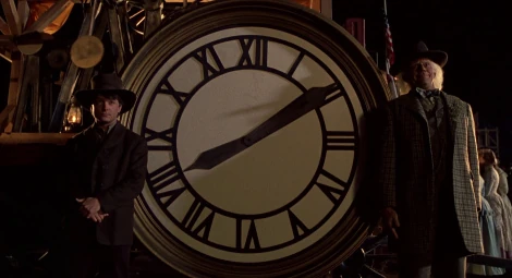
The DeLorean pulls onto a skyway above Hill Valley, California.
- "Marty leaned forward [in the passenger seat of the DeLorean], trying to get a better view of the rain-swept sky. Yeah, there were lane markers out there, small orange cones simply floating in the air."
- —From Back to the Future Part II by Craig Shaw Gardner (quote, page 13)
- "They [Doc, Marty and Jennifer] were suddenly surrounded by flying cars that didn't look all that different from the DeLorean. They must be down in the non-commercial air lanes now. The cars seemed to be going much too fast in all this rain, but then, Marty realized, there weren't any roads to slip on any more, were there?"
- —From Back to the Future Part II by Craig Shaw Gardner (quote, pages 14 and 15)
A skyway was similar to a highway and a freeway, with airspace set aside for the general public to drive flying vehicles. It was also a hovering freeway and a futuristic freeway likely with all of the freeway/or highway Interstates, US Highways, and State Routes being renamed to "Skyways" with its own number and a letter indicating the state it is in on “state” skyways and plane routes being renamed to "Hyperplanes". It is possible that some skyways had their own route though.
History[]
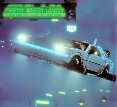
Signs and lane markers for the skyways floated in the sky; how, exactly, these remained in the air is unknown, whether it be by antigravity mechanisms or magnetism, but no thrust was involved. Skyways were constructed throughout the world sometime after 1985, and were in full operation in 2015. Local skyways connected to hyperlanes with access to major international cities on other continents. The hyperlane closest to Hill Valley, Hyperlane Grid 4, offered access to Phoenix, Boston and London.
Floating skyway signs would indicate exits, destinations, and even travel conditions for the skyway — including winds, weather and even ozone. A similar and smaller sign of the non-floating variety marked SKYWAY CONDITION — which was topped with three futuristic-looking antennas — was also present in Courthouse Square, where it was affixed to the corner of a rooftop on the building next door to the Holomax Theater and gave current travel conditions — such as "SKEWED ON", for example.
Air traffic controllers were employed to actively monitor the skyways to notify drivers of infractions of air traffic laws. All flying cars were equipped with transponders to help computers regulate the flow of traffic and for controllers to contact drivers to notify them of infractions.[1] Other standard equipment for flying vehicles were eyewear that gave live video feed behind the vehicle to the driver and a communications headset.
After departing from Lyon Estates in 1985, the DeLorean appeared in the middle of Skyway C25 in 2015, but in the wrong lane and facing oncoming traffic, almost colliding with a taxicab. Dr. Emmett Brown had to lie to an air traffic controller about a broken transponder to cover for this mistake. There were separators between the lanes, and these could move if necessary to avoid a collision, albeit returning to a fixed location in the sky. Doc brought the vehicle down, under the lane markers, and back up again into the right lane. Upon reaching the exit 'ramp' that spiraled down into Courthouse Square, Doc landed the car in an alley. The skyway was visible from the square after the scheduled rain showers ended.
Same-way traffic seems to have flowed in multiple imaginary boxes one on top of each other. The equivalent of a traffic jam was if the skyway was "skewed", with traffic being unable to move in any direction — forward, backward, up or down, though those the mayor stated it wouldn’t happen. On October 21, 2015, Skyway C25, which ran from Courthouse Square in downtown Hill Valley to Hilldale, was skewed, and even after departing during daylight, travelers that evening (namely Officers Reese and Foley of Unit N11-11, Doc and Marty, and a taxicab ferrying Old Biff Tannen) were not able to reach Hilldale until after dark.
After Marty and Doc carried Jennifer from the future McFly residence in Hilldale, they prepared to return to the past, unaware that Old Biff had altered history by stealing the DeLorean and traveling back to 1955 to give his younger self Grays Sports Almanac. It appears that speeds were very fast on the skyway even in the rain (since there is no road to skid on) at least 80 miles per hour, as Doc had to accelerate only slightly in order to reach 88 miles per hour when traveling from 2015 to what they thought to be 1985, but turned out to be a nightmarish ABC timeline where Biff controlled Hill Valley. Whether the blinding flash from time displacement or the remaining fire trails had any effect on traffic in 2015 is unknown. This indicates that there was likely no speed limit on the skyway but just laws to drive safe in the skyways though cars would be forced to stop when traffic jams occurred, though this is unknown as the speed limit could be 80 mph or 85 mph considering how fast the cars were going. When the DeLorean arrived back in 1985A, it was at an altitude that placed it slightly below the flight path of a descending commercial airliner and there was very nearly a midair collision.
Behind the scenes[]
- The floating skyway sign at the Hill Valley exit 'ramp' reads as follows:
- HYPERLANE - GRID 4 RN... [Rain] 20% VIS [Visibility]
- PHOENIX : BOSTON : LONDON
- LOCAL TRFC [Traffic] HILL VALLEY EXIT NEXT RIGHT
- The SKYWAY CONDITION sign in Courthouse Square reads as follows:[2]
- SKYWAY C25 / SKEWED ON
- OZONE:10.5% ☼ [sunny, represented by sun weather symbol, as here] W → SSE [winds blowing West to South-SouthEast]
- H 45.6% [Humidity] BP 428 [Barometric Pressure] AZ48 VT6 [what this indicates is unclear, but may possibly be the skyway equivalent of a highway route number]
- In the novelization, the lane markers of the skyway are "small orange cones" (see first Quote above), rather than the illuminated versions — which look rather like miniaturized streetlights — seen on-screen.
Actuality[]
- At the moment, the nearest thing we have to skyways is controlled airspace monitored by air traffic control directing aircraft both there and on the ground. Also, floating signs, lane markers etc. like those seen in Back to the Future Part II have yet to be invented; they are predicted to common probably by 2030 (though it most likely won’t be mainstream), since flying cars could be possibly on the market by 2021 or 2022 by Uber and Lyft.
- Digital signs similar to the floating skyway sign and Courthouse Square's SKYWAY CONDITION sign are used on highways to indicate to drivers traffic jams (which most likely would rarely happen), detours and/or delays ahead, while banking institutions have for many years displayed on their signs not only the temperature but the time as well — one example of this in the Back to the Future universe being the Bank of America in 1985. The movie makers obviously did not foresee the rise of the internet, or smartphones where one can check traffic conditions on the roads by using a website such as Google Maps, for example; or looking up weather sites such as The Weather Channel.
Appearances[]
See also[]
- Skyway C25
- Hyperlane Grid 4
 Controlled airspace on Wikipedia
 Air traffic control on Wikipedia
- Transponder on Wikipedia
- Route number on Wikipedia
References[]
- ↑ Back to the Future Part II novelization, page 14
- ↑ SKYWAY CONDITION sign - Back to the Predictions (see 'External links' below)